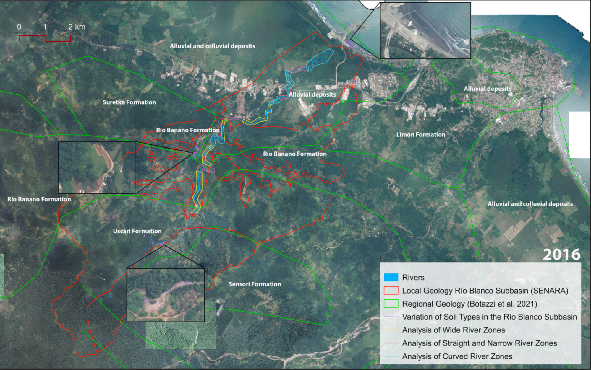
With a map of the region around the Río Blanco aquifer on the screen, we interview Rafa, a hydrogeologist who was responsible for the Hydrogeological Study of Río Blanco, about the geological specificities of the aquifer:
Well, here we have what would be the geological map of Río Blanco, and yes, this is exactly why we emphasize that it is extremely important to understand the geology of the area. Geology also involves tectonic structures, and in our case, like in Costa Rica, since we are in a subduction zone, right—where we have the Cocos Plate and the Caribbean Plate, with one subducting beneath the other—we experience a lot of stress: tension, compression, compression, block movements... and basically, we have the issue that there are areas that are literally a picadillo. The geology is all mixed up because of everything—there are faults, which are basically ruptures, right, a block that breaks into two—and sometimes one block moves down relative to the other, in other cases it rises, one rides on top of the other, or they start moving laterally. The strata bend like this, or upwards. In short, it's a total mess what can happen when you're in a zone with a very, very dynamic tectonic environment. That’s precisely the case with Río Blanco. <a class="note-call" href="#" data-content="Translated from the original: "Bueno, aquí tenemos lo que sería el mapa geológico del Río Blanco, y es que sí, resulta que por otro lado por eso es que hacemos hincapié en que es sumamente necesario conocer la geología de la zona. La geología también involucra lo que son estructuras tectónicas y en nuestro caso como Costa Rica, como somos una zona de subducción de placas, verdad, que tenemos la placa Cocos y la placa Caribe que una se sumerge dentro de la otra, debajo de la otra, tenemos una gran cantidad de esfuerzos de tensión, de compresión, de compresión, de, de bloques, y básicamente tenemos la, este, el conflicto de que, entonces, hay sectores que son literalmente un picadillo. La geología está hecha un picadillo, por todo, porque hay fallas que las fallas básicamente es una ruptura de dos, verdad, un bloque que se rompe en dos, verdad, y entonces a veces un bloque baja con respecto a otro, en otras ocasiones sube, se le monta encima o empiezan a moverse lateralmente, los estratos se hacen así, se doblan o para arriba. En fin, es una locura tremenda lo que puede pasar cuando estamos en una zona que tiene un ambiente tectónico muy, muy dinámico. Ese es un caso, por ejemplo, precisamente de Río Blanco."">Translated from the original: "Bueno, aquí tenemos lo que sería el mapa geológico del Río Blanco, y es que sí, resulta que por otro lado por eso es que hacemos hincapié en que es sumamente necesario conocer la geología de la zona. La geología también involucra lo que son estructuras tectónicas y en nuestro caso como Costa Rica, como somos una zona de subducción de placas, verdad, que tenemos la placa Cocos y la placa Caribe que una se sumerge dentro de la otra, debajo de la otra, tenemos una gran cantidad de esfuerzos de tensión, de compresión, de compresión, de, de bloques, y básicamente tenemos la, este, el conflicto de que, entonces, hay sectores que son literalmente un picadillo. La geología está hecha un picadillo, por todo, porque hay fallas que las fallas básicamente es una ruptura de dos, verdad, un bloque que se rompe en dos, verdad, y entonces a veces un bloque baja con respecto a otro, en otras ocasiones sube, se le monta encima o empiezan a moverse lateralmente, los estratos se hacen así, se doblan o para arriba. En fin, es una locura tremenda lo que puede pasar cuando estamos en una zona que tiene un ambiente tectónico muy, muy dinámico. Ese es un caso, por ejemplo, precisamente de Río Blanco."
He described the geology as a “picadillo”, which in Costa Rica is a chopped mixture which can combine many different ingredients, such as vegetables, potatoes and meat. In this case a “picadillo” is a big mixture of geological formations and sediments brought together through the centuries. A picadillo is a useful comparison to begin a discussion on pores and the crucial role they play in aquifers as it allows us to imagine a space which is not uniform, in constant flux and subject to larger geological shifts and human-based movements on the surface.
This text is a result of different sustained conversations with hydrogeologists, both in Costa Rica and the United States. Together they helped us understand this device of mediation of the underground. Pores prove to be a particularly difficult component of the aquifer world to convey, precisely because they demand a multi-scalar thinking that also breaks with scientific traditions of representation seen in models and cross sections of the underground. Pores mediate movement across scales, from the microscopic to the regional and global scales. Pores allow us to depart from the much-used tank imaginary of the aquifer, of the aquifer as a container simply waiting to be filled or emptied of its content.
Pores as Architecture
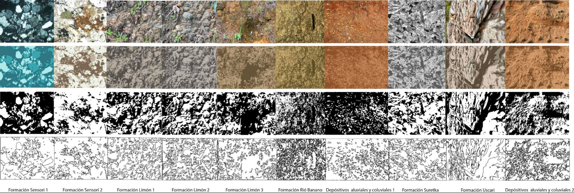
Pore space gives way to the architecture of an aquifer. A pore is a complicated void. Pores are the negative space within loosely bound sediment or rock that has the potential to be filled with water. The shape, size and distribution of the sediment determines the shape of the negative space, and therefore, how much water can be held. Porosity is the percentage of this negative space within the rock or sediment.Pore space also defines the area of saturation, how water saturates a particular material or not. There are many different kinds of porosity to consider: Open and closed porosity for example. Open porosity is where the pores are interconnected, closed porosity is where the pores are isolated from one another. The pore space is the question to be answered, as it holds the big mystery of storage capacity and therefore the potential of the aquifer to provide water. This pore space architecture is of course highly dependent on the geological specificity of the region under consideration.

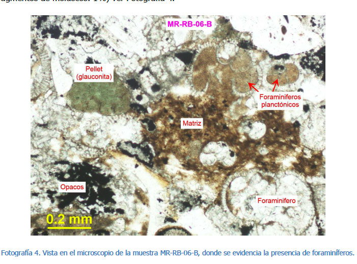
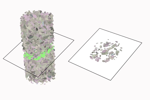
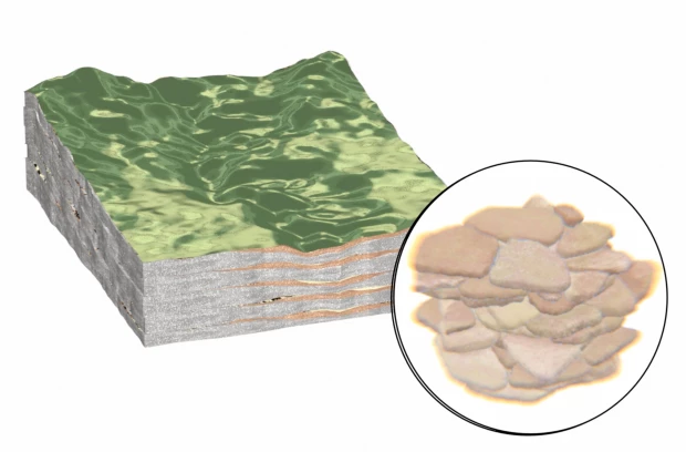
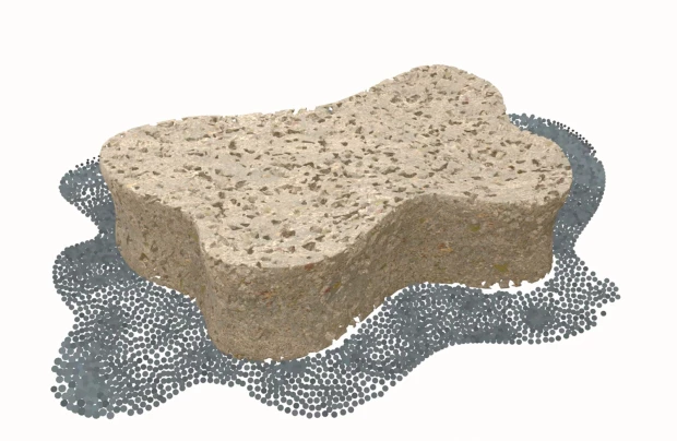
The two images above come from the Hydrogeological Study of Río Blanco and are of the geological formation called ‘Senosri’. The formation is composed of an alternation of limestone and siltstones (a stone made out of silt), interwoven with layers of sandstones and muddy gravels, sometimes interrupted by layers of coarse sandstones and gravels (Bottazzi-Basti et al., 2021).
The area around the Río Blanco aquifer is formed by stratified clayey limestones, bluish-gray in color, calcareous siltstones, and shales - reflected in the image on the right Aguilar & Denyer (2021). The formation’s thickness ranges from 1,400 to 2,400 meters in depth Fernández, Bottazzi, Barboza & Astorga (1994).

Pores and the issue of scale
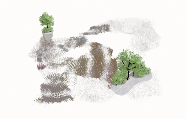
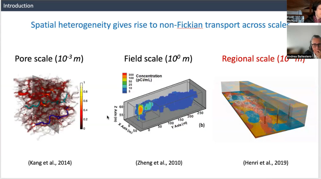
Rich describes aquifers as thin as a piece of paper, wrapped around the earth. That is how we should think about them if we think about the aquifer in its actual scale in relation to the profound depths of the subsurface. They are the tiniest fraction of the thickness of the vast world under the surface of the earth. When modeling underground aquifer systems, hydrogeologists must exaggerate the scale of the aquifer in order to render the visualization legible for their audience. Thinking through pores is another scalar mind exercise, as the pores themselves are below the threshold of human vision, they can in fact be read on many scales. As Rich explains, in following water molecules, we can observe similar patterns of transport across different scales. He describes one of his scalar visualizations demonstrating this pattern of movement:
We see similar physical patterns of transport. Pore scale, field scale and regional scale. That's a millimeter. So a thousandth of a meter. That's like what the water flow looks like. And through a pore and pore spaces and then, you know, field scale. So at a meter. So these are the size of the squares, remember I said, like, what's your representative elementary volume? Like, how big is your little box that you want to chop the world up into? If you do it at the pore scale the fields here, the regional scale, you actually see very similar patterns of how the water moves, which is, I think, an interesting, inherently interesting finding that, the heterogeneity of the environment follows a similar pattern when you're looking really closely, when you're looking kind of human scale, and then you're looking like much larger scale.
How big is that little box that you want to chop the world into? This is a question that must be answered if you wish to create a model, map, or cross section. This is a scalar decision that has consequences.
Pores as mediators of Movement
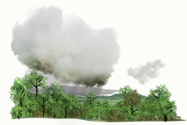
If we follow the journey of a water molecule through the hydrological cycle, we are talking about a movement that could take weeks (months if there is snowpack). However, when the molecule reaches the pore space of the underground, this journey slows down, taking years, even centuries, depending on the material the molecule of water moves through. Sand and gravel will be the fastest materials to infiltrate for a water molecule, while clay will take much longer. The pore space introduces a new kind of temporality to the hydrological cycle, and to our human relation to this cycle, as it often exceeds anthropocentric timeframes. Hydrogeologist Rich Pauloo explains this material interaction to us as follows:
Water molecules can move depending on the rock and if there's fractures in it where it can flow fast or if it's a porous rock where it's moving very slowly. You can imagine, like, something moving through like a sponge, but it's a very dense sponge, but there's interstitial space that it could diffuse in and out of and adapt through.
The architecture of the void carries a history. Sediments and their geological structures carry the information of the environments and time periods they came from. Movement is sketched into sedimentary structures throughout geological time. The structure is the imprint of movement and therefore, the historical processes of the earth that moved these materials into their current formation (which is also still in continuous movement).
In another interview, Ingrid echoes Rafa, explaining that in Costa Rica, the texture of the rocks and sediments and the prevalence of fractured rock is also influenced by the amount of seismic activity in the country. The geological dynamism of Costa Rica mediates the various forms of pores, from small pores to medium to large fractures, sometimes all combined in the same space.
What characteristics do those rocks or materials have that allow water to pass through? That’s another topic—the texture of the rock or those materials, and also other biological processes that might influence or determine the spaces that are open for water to move through. For example, fractures. In the case of Costa Rica, there are many earthquakes here, so the rocks break, they fracture, and then water finds those spaces through which it can move. So we can also talk about another classification of aquifers based on their porosity, right? If we have materials that contain small spaces or pores, we talk about porous media. Or if water moves through fractures, like in the Colima aquifer—Upper Colima, Lower Colima—we talk about fractured media. And there can also be combinations of both.
So the earth also moves. In the midst of these tectonic shifts, it also shapes the movement of the water. So to understand the aquifer one must comprehend the movement of both earth and water - both moving at different speeds - simultaneously.
The Breathing Earth: Pore-elastic Deformation
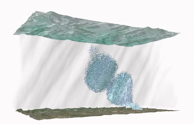
We open this text with an animation that tries to contend with two scales of pores. One is the microscopic view, where we zoom into the pore space and witness the movement of water in and out again. The other is the regional scale, the scale of the whole aquifer. On this scale we can see a process called pore-elastic deformation, which happens through the continuous movement of water throughout the hydrologic cycle.
Pore elastic deformation occurs when water is extracted from the ground. It is a transformation that occurs in the negative space, a result from the pressure of the water that was once in the pore space being removed. Once the water is removed a shrink occurs to the negative space. Most of the time this is imperceptible and unregistered. When water comes back into the pore space the process is reversed, and the pore space expands. This is what you can see in the microscopic scale animation.
And this process which occurs on the pore scale, can be seen on a regional scale, leading to a movement like that of the chest when we breathe, up and down, the earth breathing water. This breathing can be “seen” through the measurement of these small centimeter-scale movements using satellite images. Rich explains the process:
And you can even measure the pore elastic deformation. So the pores fill with water, they expand and you can see this through satellites and GPS, you can actually visualize the earth breathing like this over the seasons. So in springtime all the water melts, comes down, it's all underground. It lifts. Then people pump it up. It goes down like this. It's like centimeters, but you can see it.
Normally we don’t give the extraction of water from the surface much thought, it isn’t perceivable so it tends to go ignored, another function of life that we might take for granted. But thinking with pores and the motion of deformation draws our attention to the centrality of the hydrologic cycle in our lives, how the movement of water actually moves the ground beneath our feet.