Open Data

SmartForestsBook

2023.06.07 V1

Open Data

Table of contents

Introduction

Open Data?

The Smart Forests Atlas is a platform developed to share research and open data concerning the social-political impacts of digital technologies that monitor and govern forest environments. But what are the politics and ethics of open data in the context of forests, which have often been sites of colonial forms and technologies of data production, collection and management facilitated by dispossession, extraction and surveillance? This folio explores and practises methodologies for engaging critically and creatively with open data in the Smart Forests Atlas, with attention to democratised data infrastructures, participatory technologies of knowledge-making, and movements for Indigenous data sovereignty.

Digital Gardening & Designing the Smart Forests Atlas

2Story

Contributors
  • Michelle Westerlaken
Tags
  • algorithm
  • design
  • digital gardening
  • digital methods
  • open data
  • publication
  • publication
  • tag-cloud
  • wayfinding

In March 2021 we started the design process for this Smart Forests Atlas. This project was motivated from the need to create an open-data platform to bring together research, sensing data, and people who are involved with digital technologies in and around forests. Furthermore, we are interested in exploring new forms of digital methods and ways of building a global Smart Forests network in times where online and virtual modes of doing research have become increasingly vital.

As part of the design process, we researched available environmental open-data platforms such as Global Forest Watch, SOMAI, and Feral Atlas, and created a slide deck with our findings as well as other design characteristics we identified (see Figure 1). We then brought in design cooperative Common Knowledge, to help us further design and develop the Atlas. In May 2021 they hosted a workshop with the entire Smart Forests team as well as interviews with different participants where we shared ideas for the Atlas (see Figure 2).

During this research phase we also came across the concept and practice of Digital Gardening, via the website of designer Maggie Appleton, which inspired us to further explore this increasingly popular form of online content sharing and public knowledge making.

AtlasDesignQualities

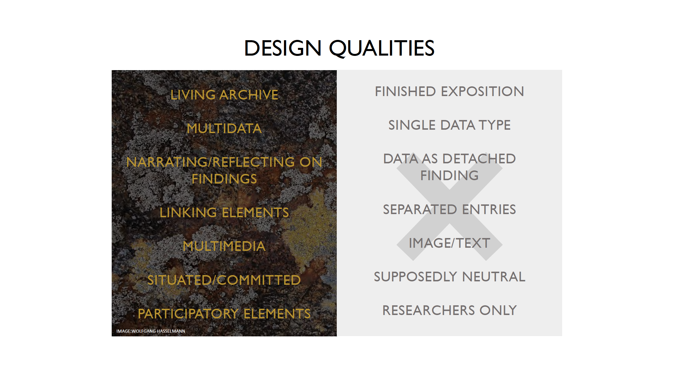
Figure 1: One of the slides from our initial slide deck, listing several desirable (left) and undesirable (right) design qualities.

CK_KickOff_Workshop

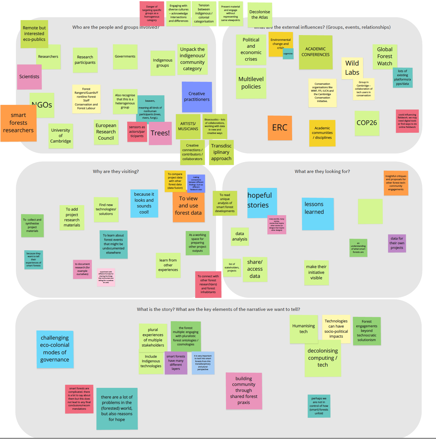
Figure 2: An image from the design workshop with Common Knowledge and the Smart Forests research team.

Digital Gardening

The idea behind Digital Gardening is to create a more playful and less linear form of sharing content online. Rather than posting content in the form of polished blog posts following a (chrono)logical order, web spaces are tended to as gardens, or wiki-style pages, where content grows more organically over time. This metaphor helped to design the Smart Forest Atlas as a digital garden where pluralistic knowledge is produced in a slower-paced environment through sharing content as seeds, saplings, and old growth, or in different stages of maturity. Plants, or pages, can grow in different directions. Weeds, or unexpected content, can flourish and change the garden. Guests are invited to travel through the Atlas through the four different wayfinding devices (Logbooks, Stories, Map, and Radio) or use the homepage’s mycelial tag network to follow their interest towards different pages during their visit.

Where Appleton described six helpful design patterns of Digital Gardening, through this process we found that while this metaphor inspired fruitful design, it could also risk reinscribing coloniality and anthropocentric design. If gardening is understood only within a Eurocentric historical perspective, it could reinforce practices of humans controlling content, limiting unwanted growth, and cultivating the ideals of a perfect botanic garden. Our work with the Smart Forests Atlas aims at further building on the idea of Digital Gardening to expand its practice and bring in developing discourses from the fields of Participatory Design and Science and Technology Studies (STS).

In our recent publication “Digital Gardening with a Forest Atlas: Designing a Pluralistic and Participatory Open-Data Platform”, Westerlaken, Gabrys, and Urzedo expand on the concept and practice of Digital Gardening and propose six additional design qualities. These include:

  1. Building Relational Commons through Open Data
  2. Enabling Epistemic Justice through Data Plurality
  3. Expanding Participation through More-than-Human Data
  4. Transforming Digital Infrastructures through Sustainable Data
  5. Cultivating Wayfinding through Unexpected Data
  6. Moving to Praxis through Open Data

More details for each of these design qualities that emerged from the Smart Forests Atlas design process can be found in the paper (available open access).

The Tag-Cloud Algorithm

Where the paper expands the concept and practice of Digital Gardening, in this post we also want to briefly detail the tag-cloud algorithm that forms the underlying structure of the Smart Forests Atlas. This tag-cloud network comes together on the Atlas homepage. This is an experimental part of the Atlas that we hope to further develop as content grows over time.

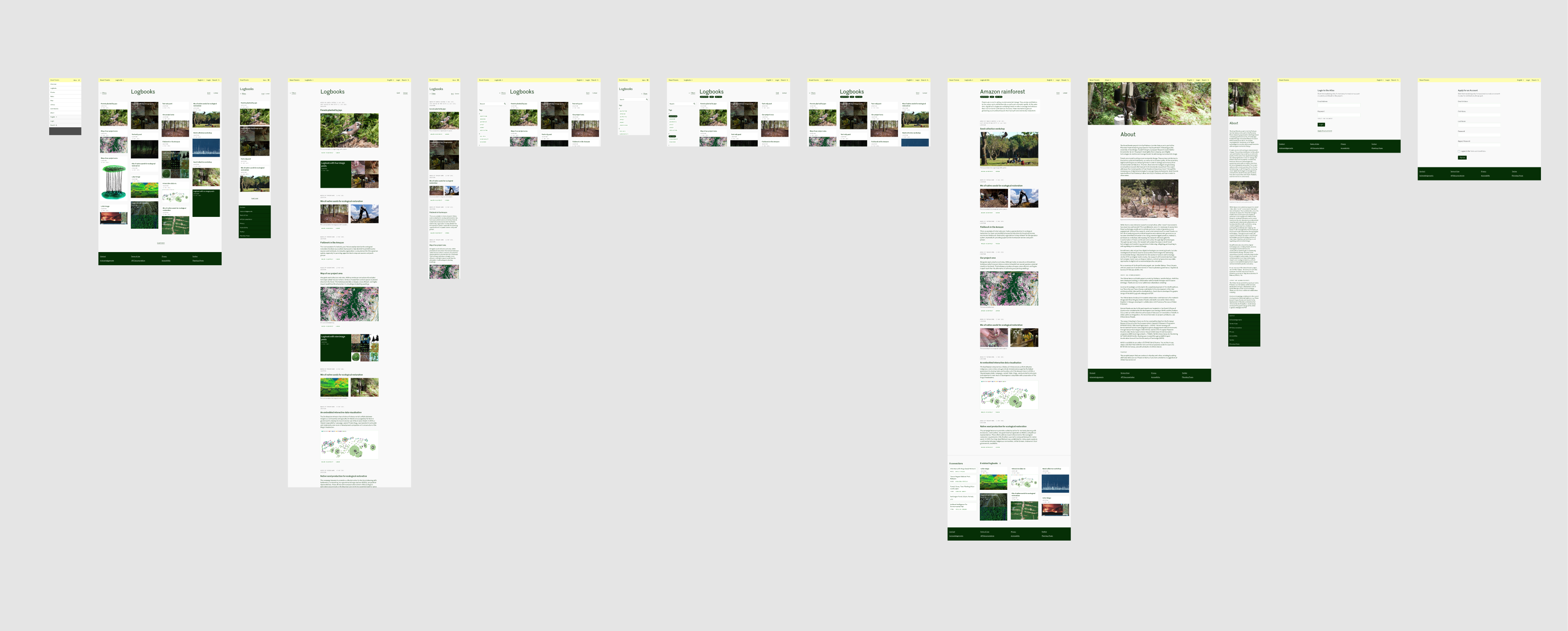
Each contributor that adds materials to the Atlas can add tags, which consist of words or phrases that describe the main content. The tag-cloud on the homepage shows the inter-relations between the tags by following a heatmap structure (see Figure 3 for an example). Each of the content pages also shows ‘related tags’ networks at the bottom of the page.

The technique that is used for the tag-cloud draws on graph theory, particularly on Eigenvector centrality, and calculates the relations between different tags. This means that tags are ranked based on how other tags link to them: when a tag has more links to other tags, the background turns brighter green. For example, the tag “open-data” in Figure 3 appears to have a high number of relations throughout the Atlas, which could both mean that the tag itself is used frequently on different pages, and/or the tag is connected to a higher number of other high-ranking tags.

During the first development and testing stage of the Atlas, we found that the number of different tags grew, and the tag-cloud became too visually dense to remain useful. Now, the homepage tag-cloud is limited to 30 tags, and when a user refreshes or returns to the homepage, the algorithm randomly selects a cluster of related tags to display. This home page thus shows different related groups of tags, rather than the entire tag network.

For the practice of Digital Gardening, this tag network helps to browse content non-linearly and enables visitors to create their own paths through the Atlas. Furthermore, the algorithm clusters content in different and often surprising ways. We hope to see the tag network and its underlying algorithm evolve as the Atlas grows in different directions.

Further documentation on the tag-cloud algorithm, as well as the actual code used, can be found on the GitHub page of this project. The GitHub project also shares all source code and detailed documentation of the website, updated by Common Knowledge.

homepage_screenshot

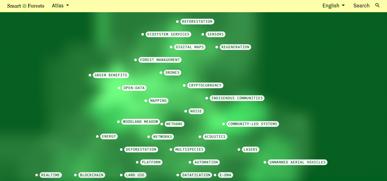
Figure 3: An example screenshot of the tag-cloud homepage. Image source: Smart Forests, Atlas Hompage [screenshot]. Retrieved May 2nd, 2022 via https://atlas.smartforests.net/en/.

For more information: Westerlaken, Michelle, Jennifer Gabrys, and Danilo Urzedo. (2022). Digital Gardening with a Forest Atlas: Designing a Pluralistic and Participatory Open-Data Platform. PDC ‘22: Proceedings of the 17th Participatory Design Conference. https://doi.org/10.1145/3537797.3537804

Africa Open DEAL

3Logbook

Contributors
  • Kate Lewis Hood
Tags
  • geospatial
  • land use
  • open data

Africa Open DEAL (Open Data for Environment, Agriculture, and Land) is an initiative set up by the UN Food and Agriculture Organization (FAO) and the African Union Commission that collected continental-scale land use data across Africa between 2018 and 2020. The project aimed to support African nations' capacities to monitor, report, and analyse environmental change through open-data geospatial technologies. The data survey classified 26% of land in Africa as forest, and also identified 7 billion additional trees outside of forests.

Open Data for Environment, Agriculture and Land

AfricaOpenDEAL
A map showing land use data collected for Africa Open DEAL. Image source: FAO [screenshot]. Retrieved 28 September 2022, from https://www.fao.org/3/cb5896en/cb5896en.pdf

The data for Africa Open DEAL was collected by African land use and GIS experts using the open-source software Collect Earth, through workshops and Mapathons (group data collection sessions), as a digital statistical sampling-based assessment of continental land use. Collect Earth facilitates analysis of high-resolution satellite imagery, enabling practitioners to assess and record land use, transition, and degradation based on classifications used in international frameworks such as the United Nations Convention to Combat Desertification (UNCCD). What do these large-scale digital tools and data collection models make visible, and what might their categorisations obscure?

Great Green Wall

Begun in 2007 as a tree-planting initiative in the Sahel region, the Great Green Wall is a rural development project involving large-scale landscape restoration across Africa, with an emphasis on working towards the UN's Sustainable Development Goals (SDGs) on food and water security, climate resilience, and social and gender equity. The Pan-African Agency of the Great Green Wall (PA-GGW) extended the project to belts in North and Southern Africa, and supported the Africa Open DEAL.

The Great Green Wall is currently developing a Great Green Wall Accelerator online platform to support the coordination, monitoring, and measurement of project impact. GGW also uses a range of digital tools to communicate project progress, from interactive storymaps to a virtual reality film and app.

Crowther Lab

4Logbook

Contributors
  • Kate Lewis Hood
  • Jennifer Gabrys
  • Michelle Westerlaken
Tags
  • datafication
  • platform
  • reforestation
  • remote sensing
  • restoration

The Crowther Lab, led by ecologist Thomas Crowther at ETH Zürich, is a team of scientists researching global ecological systems, climate regulation, and restoration. Prior to starting the lab, Crowther mapped tree cover at a global scale and tracked decline in tree numbers. The lab identifies possibilities and practices for global tree restoration as a way to capture atmospheric carbon with the aim of mitigating climate change. A major project of the Crowther Lab is Restor, an online open-data platform for the global restoration movement.

Restor

Restor is an open-data platform sharing deforestation and restoration data. The platform, currently in beta, is developed by ETH Zurich’s Crowther Lab in collaboration with Google. This image, for example, shows a site in the Central Kalimantan region that has been deforested and undergoing active restoration. Different layers reveal how this area of land has changed over time.

Restor

Image of Restor - Heidehof site in Central Kalimantan. Image source: Restor [screenshot]. Retrieved January 27, 2022 from https://restor.eco/

Mapping Global Forest Cover

Two important scientific papers, the first by Crowther et al. (2015) in Nature and the second by Bastin et al. (2019) in Science, broke new ground in estimating global tree density and and potential carbon sequestration through tree restoration as a highly effective approach to climate change. These papers were widely reported in the media and influenced a proliferation of tree-planting organisations and operation. Since publication, both other scientists and the authors themselves have sought to complicate the positioning of tree planting as a straightforward solution, debating the figures about carbon sequestration, the relationship between forest and grassland ecologies, and the ecological dynamics to be considered in tree restoration.

Learn more about this work in our radio episode with Thomas Crowther.

Native Land Information System

5Logbook

Contributors
  • Kate Lewis Hood
Tags
  • datafication
  • data visualisation
  • land cover
  • land use
  • mapping
  • restoration

The Native Land Information System (NLIS) and related Native Lands Advocacy Project (NLAP) have developed a set of maps and data tools to support Tribes and Native communities to exercise sovereignty in habitat preservation and expansion, agricultural and food systems, and climate adaptation, with a focus on protecting and restoring Indigenous relations to land and non-human relatives.

Preserving Intact Habitat on US Native Lands Storymap

NLAP_IntactHabitatMap

Screenshot of the Preserving Intact Habitat on US Native Lands map. Image source: Native Lands Advocacy Project [screenshot]. Retrieved 13 July 2022, from https://nativeland.info/blog/storymaps/preserving-intact-habitat-on-us-native-lands/

The Preserving Intact Habitat on US Native Lands storymap contextualises data on 'intact habitat' from the GIS company Esri's Green Infrastructure Initiative, with a particular focus on how this data can be mobilised by Native communities. Intact habitat refers to interconnected natural habitats and landscapes that are minimally fragmented or disturbed by infrastructure and industry, and the Native Lands Advocacy Project adopts this framework with the aim of promoting biodiversity, protecting cultural sites, and adapting and responding to environmental change. The map allows users to slide between a layer showing intact habitat cores and a layer showing land cover types, with Native lands marked out on both.

A central aspect of the storymap and NLAP's wider work is data sovereignty, which NLAP describes as 'the right of tribes to control what data is collected on their lands and among their members as well as who has access to that data', challenging colonial forms of data collection that have been operationalised in attempts to control and contain Indigenous peoples and lands. The Native Land Information System's maps and datasets provide practical tools for Native communities responding to climate colonialism, while also raising broader questions for smart forest projects about the conditions and contexts of datafication in forest environments.

Global TLS Network

6Logbook

Contributors
  • Kate Lewis Hood
Tags
  • forest monitoring
  • lasers
  • networks
  • open data

The Global Terrestrial Laser Scanning (TLS) Network is a network of researchers using ground-based lasers to produce 3D data on forest structure and dynamics. Terrestrial laser scanning works by emitting laser pulses and generating a 3D point cloud from the way that these laser pulses are reflected back. TLS was first used in forests to measure tree height and diameter, and has subsequently been developed for more complex forest and ecosystem monitoring. The Global TLS Network website shows where TLS research is taking place, and provides information about the conditions of research sites and the availability of open data.

Virtual 3D TLS Forests

A group of researchers (Calders et al. 2018) made a virtual 3D model of one hectare of Wytham Woods, a mixed deciduous forest managed by the University of Oxford that has been used for ecological research since the 1940s. Using terrestrial laser scanning and open-source software, they explore how remote sensing measurements can contribute to understandings of the biophysical properties of forests.

Wytham Woods TLS

A point cloud of one hectare of Wytham Woods, generated through terrestrial laser scanning (TLS). Image source: Calders et al. (2018). Retrieved 1 June 2023, from https://doi.org/10.3390/rs10060933

Researcher Kim Calders also made an animated video of a virtual walk through Wytham Woods, using TLS data. In the animation we move through the trees, not confined to the places where humans could walk, and we also see structures and devices that facilitate research in the forest, such as scaffolded walkways and measuring devices. Whose perspective(s) are we seeing the woods through, and what is revealed and obscured in the environment through this virtual 3D model?

TLS and Carbon

Wytham Woods TLS 2022

3D TLS data from Wytham Woods, showing the top of the canopy and some individual trees. Image source: Calders et al. (2022). Retrieved 1 June 2023, from https://doi.org/10.1002/2688-8319.12197

More recent work (Calders et al. 2022) uses TLS to help evaluate existing models for estimating tree biomass, which is important for calculating potential carbon sequestration. Using TLS data, Calders and colleagues suggest that biomass – and, relatedly, carbon stocks – in temperate forests like Wytham Woods may be higher than often-used allometric models estimate. These kind of measurements – not only what they measure but also how and where they are made – can have significant implications for an increasingly quantified approach to forest carbon (and its valuing) in the context of climate change.

The Forest Multiple: Tone Walford

7Radio Episode

Tags
  • Amazon rainforest
  • datafication
  • Forest Multiple
  • monitoring
  • open data

This radio episode, recorded at The Forest Multiple symposium in October 2022, features a panel talk by Dr Tone Walford, Lecturer in Digital Anthropology at University College London. Tone's paper, "The Post-environmental Condition? The Data Frontiers of Environmental Science in the Brazilian Amazon" discusses the social worlds of environmental data and the complexities of data production, ownership, commercialisation, and open data.

Panel chair: Tami Okamoto, University of Cambridge

Producer: Harry Murdoch

Workshop

Open data, ethics and sovereignty

How are we approaching questions of open data through the design and content of the Smart Forests Atlas? What are the politics of open data where forests have been used as tools and technologies of colonial knowledge production and spatial control? How do different communities we engage with conceptualise and complicate understandings and practices of (open) data? What ethical practices could we envision and develop for engaging with environmental and more-than-human data? These are ongoing questions we are exploring through Smarts Forests.

Following conversations with our advisory board, we held a workshop in May 2023 to discuss the complexities of open data in the practices and principles of the Smart Forests Atlas. During the workshop…

Credits

For more information on the Smart Forests project, contact Prof Jennifer Gabrys.

Follow us on Twitter for the latest updates on the Smart Forests project and the Planetary Praxis research group.

This project has received funding from the European Research Council (ERC) under the European Union’s Horizon 2020 research and innovation programme (Grant Agreement No. 866006).

The Smart Forests Atlas is free to use for non-commercial purposes (with attribution) under a CC BY-NC-SA 4.0 license. For more information, please read our licence.

Thanks to…

Number of copies: 1000
Fonts: Monaco, Marr
Design process: web to print, API, pagedjs
Graphic design: Angeline Ostinelli and Sarah Garcin

The Smart Forests Atlas is a platform developed to share research and open data concerning the social-political impacts of digital technologies that monitor and govern forest environments. But what are the politics and ethics of open data in the context of forests, which have often been sites of colonial forms and technologies of data production, collection and management facilitated by dispossession, extraction and surveillance? This folio explores and practises methodologies for engaging critically and creatively with open data in the Smart Forests Atlas, with attention to democratised data infrastructures, participatory technologies of knowledge-making, and movements for Indigenous data sovereignty.